

Last verified December 2024
The Alpine Loop Backway is a 65-mile mountain loop in the San Juan Mountains of Colorado that connects the towns of Silverton and Ouray with Lake City.
Resources
The Alpine Loop Backway is a 65-mile mountain loop in the San Juan Mountains of Colorado that connects the towns of Silverton and Ouray with Lake City.
The trail, which passes through San Juan National Forest, reaches an elevation of 12,800 feet as it passes through dramatic alpine tundra and old mining ghost towns from the 1880s, such as Animas Fooks and Capitol City.
Route Details
Length
65 miles
States
Colorado
Time of Year
Upper passes are typically opened in May or early June and close again in late October. Areas at lower altitudes open earlier in the season. Check with the National Forest Service office to find out what’s open.
Vehicle requirements
You can access about two-thirds of the route in a two-wheel drive, but to complete the entire loop through the high-mountain passes you’ll need a high-clearance four-wheel drive.
More information
Colorado Tourism Office Guide and San Juan National Forest website and brochure (PDF).
Alpine Route Overview

The Alpine Loop is a breathtaking off-road route winding through the rugged San Juan Mountains in southwestern Colorado. Spanning approximately 65 miles, the loop connects the historic towns of Lake City, Silverton, and Ouray, offering adventurers a chance to explore high alpine terrain, ghost towns, and remnants of Colorado’s mining history. This trail is renowned for its challenging passes, jaw-dropping scenery, and a unique blend of history and natural beauty.
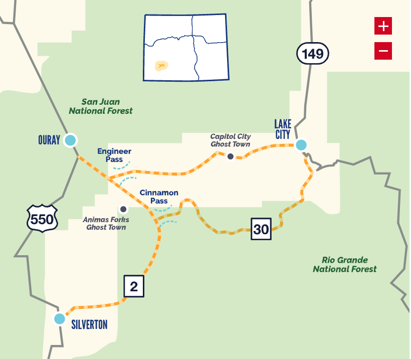
The loop, designated as a backcountry byway, features steep climbs, rocky sections, and high-altitude passes exceeding 12,000 feet, including Engineer Pass and Cinnamon Pass.

It is an all-day experience for those tackling it in one go, but its numerous side routes and points of interest make it a multi-day adventure for overlanders looking to immerse themselves in the remote backcountry.
This trail requires a high-clearance, four-wheel-drive vehicle and a good level of off-road driving skill. The route is best attempted during the summer and early fall, as snow and ice can make the trail impassable for much of the year.


Getting to the Alpine Loop
Access to the Alpine Loop is possible from three primary entry points:
- Lake City: Enter the loop via County Road 30 or County Road 20.
- Silverton: Access the loop from County Road 2.
- Ouray: Start the loop from County Road 18.
These roads lead to the loop’s main route, and signage for the Alpine Loop is visible near the trailheads. It is crucial to prepare adequately by downloading or printing detailed maps, as cell service is limited or nonexistent in many areas.
The Trail

The Alpine Loop offers a mix of high-altitude adventure, historical exploration, and stunning natural landscapes. Key highlights of the trail include:
- Engineer Pass: One of the most iconic passes on the route, Engineer Pass reaches an elevation of 12,800 feet and offers panoramic views of the surrounding peaks. The ascent is steep and rocky, requiring careful navigation.
- Cinnamon Pass: Another high-altitude pass, Cinnamon Pass provides access to alpine meadows filled with wildflowers and incredible vistas. The descent into Animas Forks is steep but less technical than Engineer Pass.
- Ghost Towns: The trail passes several abandoned mining towns, including Animas Forks, which features well-preserved structures and interpretive signs detailing the area’s history.
- Scenic Beauty: The trail winds through diverse terrain, including dense forests, open meadows, and rocky alpine tundra. Wildlife such as elk, marmots, and even the occasional black bear can be spotted along the route.
Trail Conditions and Requirements
The Alpine Loop is a challenging trail with steep inclines, loose rocks, and narrow sections that require caution and skill to navigate. High-clearance 4WD vehicles are essential to complete the entire routh, and drivers should carry recovery gear, spare tires, and extra fuel. Adequate food, water, and warm clothing are also necessary due to the remote nature of the trail and rapidly changing weather conditions.
Nearby Camping and Accommodations
There are numerous camping opportunities along the Alpine Loop, from dispersed sites to developed campgrounds. Popular options include:
- Lake San Cristobal: Located near Lake City, this area offers developed campgrounds with scenic lake views.
- Animas Forks: Dispersed camping is available near the ghost town, offering a unique historical backdrop.
- Silverton and Ouray: Both towns feature campgrounds, cabins, and lodging for those seeking a base before or after the loop.
Tips for a Safe Journey
- Notify someone of your travel plans and expected return.
- Carry a GPS device or offline maps.
- Check weather conditions before starting, as storms can make the trail dangerous.
- Avoid traveling alone if possible, and bring recovery gear in case of an emergency.